

SUGAR LAND, Texas (July 14, 2014) — Steve Maliszewski, employee of construction software firm HCSS, is set to run one of the toughest foot races on the planet: the grueling 135-mile Badwater Ultramarathon in California taking place July 21-23. To track him along the course, HCSS is installing one of its GPS units—a product that Maliszewski helped design—on his crew’s van to follow his progress in real time. HCSS’s GPS units provide detailed location data and can track vehicle speeds and record mileage.
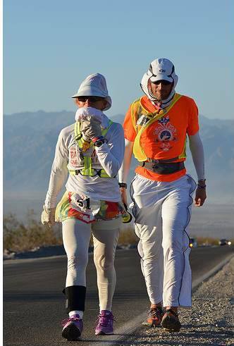 HCSS employee Steve Maliszewski (right), photographed as a crew member for a competitor in the 2013 Badwater Ultramarathon
Starting in the small town of Lone Pine, Calif., at 3,727 feet above sea level, the race starts with a 22-mile climb to 10,000 feet and ends at 8,360 feet at the Whitney Portal, the trailhead to Mount Whitney. Taking place in the middle of July when temperatures soar to 120 degrees Fahrenheit, winds radiating off the hot asphalt can hit temperatures of 170 degrees.
The competition is elite with only 100 runners participating from across the globe, and acceptance is based on an application akin to a college application. Maliszewski had to write essays, provide recommendations and must have competed in three 100-mile races within the last few years. Maliszewski is one of six runners from Texas, and this is his first time to compete at Badwater. Each runner brings a crew and support vehicle that stays within two miles of the competitor carrying food, water and medical supplies.
Competitors are given 48 hours to complete the course. Maliszewski hopes to finish in the 30-hour range, which puts his pace at a 12-minute mile. “You try to pace yourself,” says Maliszewski. “I imagine at times it will be slower, especially on the bigger climbs. At times I’ll be running an eight-minute mile, and at times I will walk.”
HCSS is building a webpage dedicated to tracking Maliszewski that shows the map of the Badwater route and the GPS unit flashing his progress throughout the race. The company will draw geofences around each of the way point stops, so that each time the support vehicle enters or exits one of these points, an instant message will be sent to his followers via HCSS’s Twitter feed (twitter.com/hcss). HCSS customers employ HCSS GPS for similar purposes: it was developed to help construction companies monitor driver behavior, provide location data, track speeds, provide theft alerts and automate meter readings.
Members of his crew will be documenting his journey for supporters to see Maliszewski in his element. They can follow him through the race here or on Twitter at twitter.com/hcss#steverunsbadwater.
For more information, visit http://hcss.me/badwater2014